


 English
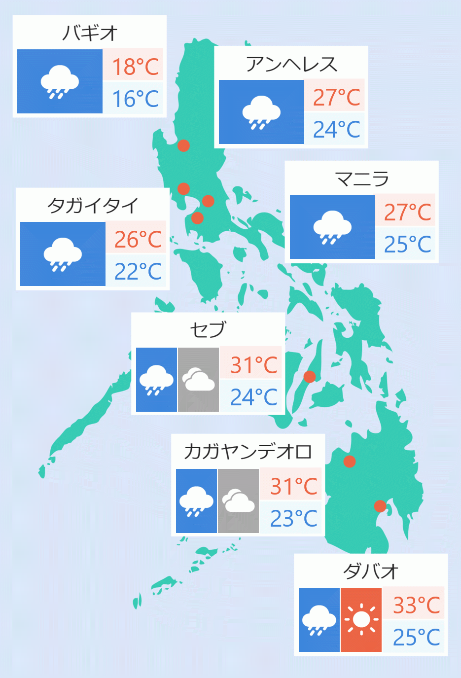
Tropical cyclone wind signal number four was raised by the Philippine Atmospheric Geophysical and Astronomical Services Administration (Pagasa) in three provinces directly affected by Typhoon ''Emong'' in the western part of Luzon on Thursday.
''Emong'' which was developed into typhoon on Thursday morning, made a U-turn while moving towards the coastal waters of Pangasinan.
The typhoon is expected to accelerate and make landfall or pass very close to northwestern Pangasinan on Thursday night.
"The typhoon may also make landfall in La Union or Ilocos Sur this late evening or tomorrow (Friday) early morning. It will then cross the mountainous terrain of Northern Luzon and emerge over the Babuyan Channel tomorrow morning or noon," Pagasa said.
It also added that "'Emong' will move northeastward and pass close or over Babuyan Islands between tomorrow (Friday) noon and afternoon. It may also be passing near Batanes between tomorrow afternoon or evening."
As of 5pm, the typhoon was last spotted over the coastal waters of Burgos, Pangasinan with maximum sustained winds of 120 kph near the center and gustiness of up to 150kph while slowly moving east southwestward.
The areas under signal number four includes "the southwestern portion of Ilocos Sur (Santa Lucia, Santa Cruz, Tagudin), the northwestern portion of La Union (Bangar, Luna, Balaoan, Bacnotan, San Juan, City of San Fernando, Bauang), and the extreme northwestern portion of Pangasinan (Agno, Bani, Bolinao, Anda, City of Alaminos)."
"The rest of Ilocos Sur, the rest of La Union, the northern and western portions of Pangasinan (Burgos, Dasol, Mabini, Lingayen, Bugallon, Infanta, Labrador, Sual, Dagupan City, San Fabian, Binmaley), the southern portion of Abra (San Quintin, Langiden, Manabo, Pidigan, Luba, Tubo, Villaviciosa, Pilar, Penarrubia, San Isidro, Bangued, Danglas, La Paz, Tayum, Boliney, Sallapadan, Bucloc, Bucay, Dolores, Lagangilang, Licuan-Baay, Daguioman), the western portion of Mountain Province (Besao, Tadian, Sagada, Bauko), and the western portion of Benguet (Sablan, Kapangan, Mankayan, Tuba, Bakun, Kibungan)" were placed under signal number three.
The state weather bureau also placed "Ilocos Norte, the rest of Pangasinan, the rest of Abra, Apayao, Kalinga, the rest of Mountain Province, Ifugao, the rest of Benguet, Babuyan Islands, the northern and western portions of mainland Ilocos Norte, the rest of Pangasinan, the rest of Abra, Apayao, Kalinga, the rest of Mountain Province, Ifugao, the rest of Benguet, Babuyan Islands, the northern and western portions of mainland Cagayan (Rizal, Santa Praxedes, Claveria, Sanchez-Mira, Pamplona, Abulug, Ballesteros, Aparri, Camalaniugan, Allacapan, Buguey, Santa Teresita, Santa Ana, Gonzaga, Lal-Lo, Lasam, Santo Nino, Piat, Tuao), the western portion of Nueva Vizcaya (Kayapa, Santa Fe, Ambaguio, Aritao, Bambang, Bayombong, Villaverde, Solano, Bagabag), and the northern portion of Zambales (Masinloc, Candelaria, Santa Cruz, Palauig, Iba)" under signal number two.
Signal number one was also raised over "Batanes, the rest of Cagayan, the western and central portions of Isabela (Santo Tomas, Delfin Albano, Quezon, Mallig, Quirino, Roxas, San Manuel, Aurora, San Mateo, Ramon, Cordon, Burgos, Cabatuan, Cabagan, San Pablo, Santa Maria, Tumauini, Gamu, Luna, Maconacon, Alicia, San Mariano, Naguilian, San Guillermo, City of Cauayan, Echague, Ilagan City, Angadanan, Benito Soliven, City of Santiago, Reina Mercedes, San Agustin, Divilacan, San Isidro, Jones), Quirino, the rest of Nueva Vizcaya, the rest of Zambales, Tarlac, the northern portion of Pampanga (Porac, Floridablanca, Angeles City, Mabalacat City, Magalang), and the western and central portions of Nueva Ecija (Carranglan, Lupao, Talugtug, Cuyapo, Nampicuan, Guimba, Science City of Munoz, San Jose City, Pantabangan, Rizal, Llanera, Talavera, Santo Domingo, Quezon, Licab, Aliaga, Zaragoza, San Antonio, Jaen, Cabanatuan City, Santa Rosa, General Mamerto Natividad, Palayan City, Bongabon, Laur".
On the other hand, Tropical Storm ''Dante'' exited the Philippine Area of Responsibility (PAR) around 3 pm Thursday while the low pressure area outside the PAR has now developed into tropical depression. Robina Asido/DMS